
Teacher Edition | View the Map
Week of March 24, 2024
Right click and SAVE AS
to download the Google Earth file for this episode
Use free Google Earth software
to OPEN it, using File> Open.
Find more tech info here.
Text from Louie: Pontchartrain Hotel is gr8.
So now we are going to try to figure out where this hotel is located and head there as soon as we can. Wish us luck!
- Meri
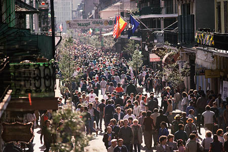
Here is a picture we found of Mardi Gras. There are a LOT of people!
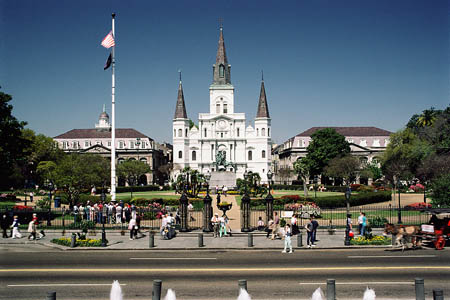
This is the St. Louis cathedral. Isn't it beautiful?
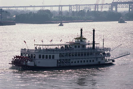
A picture of a river boat on the great Mississippi River!
New Orleans has one of the busiest and largest ports in the entire world! The city is located in southeastern Louisiana, right near the Mississippi River, Lake Pontchartrain (do you remember what hotel we are looking for?), and Lake Borgne. The city is a little over 100 miles from the Gulf of Mexico. New Orleans has a total area of about 350 square miles, close to half of which is water! The city is actually located on the Mississippi river delta. The area along the river has many ridges and hollows.
The exact map coordinates for New Orleans are 29 degrees latitude and -90 longitude. The climate of New Orleans is classified as a humid subtropical climate. The winters are short and mild. The summers are very hot and humid. The city gets about 64 inches of rain each year. The summer months have the most rain. New Orleans also experiences the threat of hurricanes. This city has a higher risk of hurricanes because of its low elevation. It has been referred to as Louisiana's sinking coast because the city is surrounded by water from the north, south, and east. Several severe hurricanes have struck the area. The most damaging was Hurricane Katrina in 2005. Thankfully, by the time the hurricane hit, most of the residents of the city had evacuated (or left the city). However, the damage was still terrible and nearly the entire city was flooded. Some people even lost their lives. It was a terrible tragedy in United States history.
We do have some exciting Louie news. Earlier today Uncle GT came and picked us up to head to the airport. We sent a photo to the Pontchartrain Hotel and shared our ONE picture of Louie with the people working there in guest services. They said they had seen a man who looked very similar to Louie walking around the area with a mask on his face and talking all about the French Quarter? But since they couldn't see his face, they couldn't be 100% sure it was him. Neither Meri nor I had any idea what the French Quarter was, so we researched a bit. It is actually the oldest and most famous neighborhood in New Orleans. There are many historical buildings and beautiful architecture. We are still curious about WHY Louie would be wearing a mask? Could he really think it is still Mardi Gras? They said it wasn't a medical mask. This story just keeps getting crazier!
Here is a question for you - do any of our followers know what the capital of Louisiana is? Take a look at the state map below and see if you can find its capital city.
- Geo
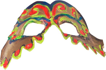
This is the kind of mask that Louie was wearing, according to the people who saw him.
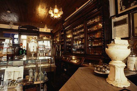
Here is an old pharmacy that we saw in photos of New Orleans.
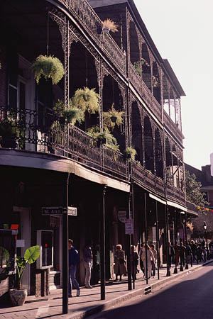
Here is a street found in the French Quarter of New Orleans. I love the balconies. I wish we could have seen this!
Map of Louisiana
Check out this map (be sure to take a look at the legend). Can you figure out which city is the state capital of Louisiana? What other information do they give you in the legend?
climate - the weather in a particular area: including temperature, precipitation, and wind.
elevation - the altitude (or how high) a location is above sea level.
hollows - indented areas on the surface of the earth.
humid subtropical climate - a climate with hot, humid summers and cool winters.
hurricanes - severe tropical storms with heavy rains and high winds.
hurricanes - severe tropical storms with heavy rains and high winds.
hurricanes - severe tropical storms with heavy rains and high winds.
map coordinates - numbers that provide the exact location of a specified country or other area. The coordinates provide the degrees of longitude and latitude. Coordinates help people locate specific areas on a map.
port - a place on a waterway with facilities for loading and unloading ships (cargo, passengers, etc.).
ports - places on a waterway with facilities for loading and unloading ships (cargo, passengers, etc.).
ridges - geological features that have a continuous elevational crest for a significant distance. They may also be called hills or mountains.
river delta - the triangular piece of land (usually sand and soil) that is located at the mouth (or inlet) of a river where it meets salt water.
Back to top
Grade 3-5: Knows the basic elements of maps and globes (title, legend, cardinal, scale, grid, meridians, time zones, etc.).
Grade 3-5: Uses map grids (e.g., latitude and longitude or alphanumeric system) to plot absolute location.
Grade 3-5: Knows major physical and human features of places as they are represented on maps and globes. Knows how to read different maps: road, relief, globe, etc..
Grade 3-5: Knows the location of major cities in North America.
Grade 3-5: Knows the approximate location of major continents, mountain ranges, and bodies of water on Earth.
Grade 6-8: Knows the location of physical and human features on maps and globes (e.g., culture hearths such as Mesopotamia, Huang Ho, the Yucatan Peninsula, the Nile Valley; major ocean currents; wind patterns; land forms; climate regions).
Grade 3-5: Knows different methods to measure data (miles, kilometers, time, etc..).
Grade 3-5: Knows the characteristics of a variety of regions (climate, housing, religion, language, etc..).
Grade 6-8: Understands criteria that give a region identity (such as Amsterdam as a transportation center or the Sunbelt's warm climate and popularity with retired people).
Grade 6-8: Knows how places and regions serve as cultural symbols (Opera House in Sydney or Tower Bridge in London).
Grade 3-5: Knows the physical components of Earth's atmosphere (weather and climate), lithosphere (land forms such as mountains), hydrosphere (oceans, lakes and rivers), and biosphere (vegetation and biomes).
Grade 6-8: Knows the consequences of a specific physical process operating on Earth's surface (e.g., effects of an extreme weather phenomenon such as a hurricane's impact on a coastal ecosystem, effects of heavy rainfall on hill slopes, effects of the continued movement of Earth's tectonic plates).
Grade 3-5: Knows how and why people divide Earth's surface into political and/or economic units (e.g., states in the United States and Mexico; provinces in Canada; countries in North and South America; countries linked in cooperative relationships, such as the European Union).
Grade 6-8: Understands the symbolic importance of capital cities (such as Canberra, a planned city, as the capital of Australia).
Grade 3-5: Knows how communities benefit from the physical environment (e.g., people make their living by farming on fertile land, fishing in local water, working in mines; the community is a port located on a natural harbor, a tourist center located in a scenic or historic area, an industrial center with good access to natural resources).
Grade 3-5: Knows natural hazards that occur in the physical environment (floods, tornadoes, earthquakes, etc..).